The Woman Who Drew the Ocean's Secrets While Science Erased Her Name
The Woman Who Drew the Ocean's Secrets While Science Erased Her Name
In 1952, Marie Tharp sat in the basement of Lamont Geological Observatory, surrounded by thousands of sonar readings that most scientists considered meaningless noise. The data came from Navy ships crisscrossing the Atlantic, their echo sounders bouncing signals off the ocean floor to measure depth. To everyone else, the numbers were just navigation aids. To Tharp, they were pieces of an enormous puzzle that would reshape humanity's understanding of Earth itself.
 Photo: Lamont Geological Observatory, via sustainableridgewood.org
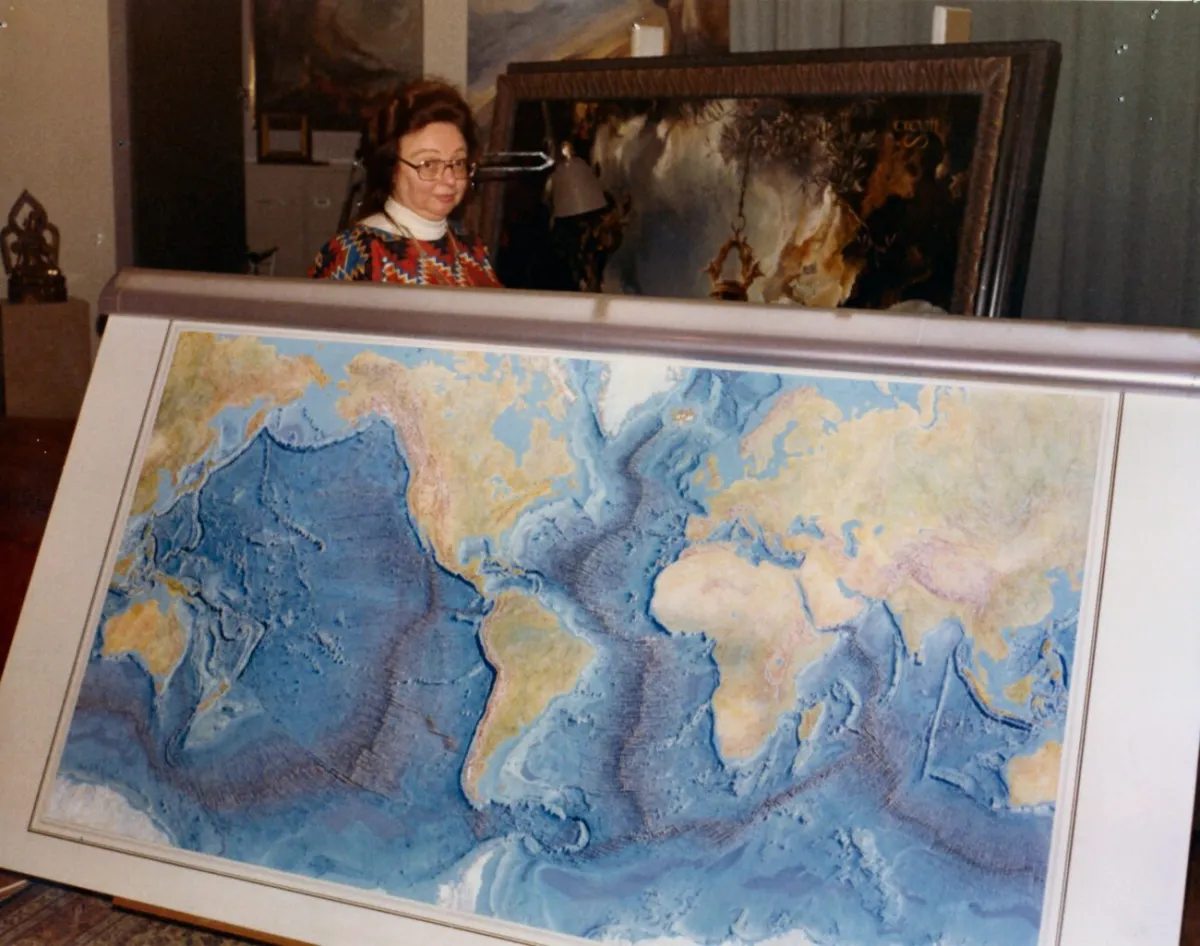 Photo: Marie Tharp, via media.news.climate.columbia.edu
She wasn't supposed to be there. Women weren't allowed on research vessels, so while male colleagues sailed the world's oceans gathering data, Tharp remained landlocked, translating their numbers into something no one had ever seen before: detailed maps of the ocean floor.
The Accidental Cartographer
Tharp never intended to become the woman who would map the bottom of the sea. Born in 1920 in Ypsilanti, Michigan, she grew up following her father, a soil surveyor, around the Midwest. She learned to read topographic maps before she could properly read books, developing an intuitive understanding of how land forms translated into lines on paper.
After earning degrees in English, music, geology, and mathematics, she arrived in New York in 1948 looking for work. The geology department at Columbia University had exactly one position available for a woman: research assistant to a young graduate student named Bruce Heezen, who was studying the ocean floor.
It was supposed to be temporary. It became her life's work.
Drawing the Invisible
The partnership between Tharp and Heezen began with a simple division of labor that reflected 1950s gender roles. He would go to sea and collect data. She would stay behind and process it. Neither of them anticipated that this arrangement would lead to one of the most significant discoveries in Earth science.
Tharp's job was to transform sonar readings into profiles—cross-sectional views of the ocean floor. She would plot thousands of depth measurements on graph paper, connecting the dots to reveal the underwater landscape. It was painstaking work that required extraordinary attention to detail and spatial reasoning.
Most researchers treated these profiles as simple navigation tools. Tharp saw something else entirely. As she accumulated more and more cross-sections of the Atlantic, she began to notice patterns that suggested something remarkable: a continuous underwater mountain range running down the center of the ocean basin.
The Discovery That Changed Everything
In 1952, while working on a profile of the North Atlantic, Tharp noticed something that made her heart race. Running along the crest of the underwater mountain range was a deep valley—a rift that seemed to split the seafloor like a giant crack.
She immediately understood the implications. The rift suggested that the seafloor was spreading apart, creating new ocean floor in the process. This would support Alfred Wegener's controversial theory of continental drift, which most geologists had rejected as impossible.
When she showed her findings to Heezen, his response was swift and dismissive: "It can't be. It looks like continental drift, and that's impossible."
But Tharp was certain. She had seen the pattern repeated across multiple profiles. The Mid-Atlantic Ridge, as it would later be known, was real, and it was actively spreading.
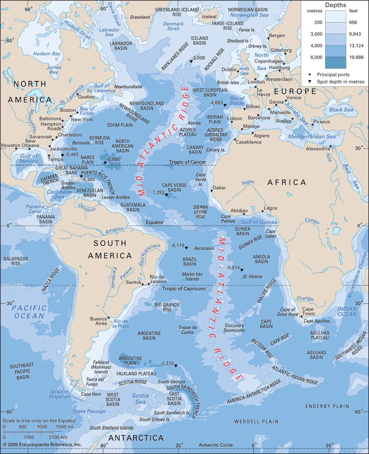 Photo: Mid-Atlantic Ridge, via cdn.britannica.com
Fighting for Recognition
For the next several years, Tharp continued mapping while Heezen remained skeptical. She expanded her work to other ocean basins, discovering that the underwater mountain ranges formed a continuous system spanning the globe. Her hand-drawn maps revealed features that no one had imagined: vast rift valleys, underwater canyons deeper than the Grand Canyon, and seamounts rising from the abyssal plains.
When Heezen finally accepted her interpretation, he began presenting their findings at scientific conferences. But in the male-dominated world of 1950s geology, Tharp's role was systematically minimized. Papers were published under Heezen's name alone or with Tharp listed as a junior author despite her doing the bulk of the analytical work.
"I was never allowed to go to sea," Tharp later recalled. "But in some ways, that was a blessing. If I had been on the ships, I would have been expected to do the cooking and cleaning. Instead, I got to do the science."
The Map That Proved Everything
In 1977, Tharp and Heezen published their masterpiece: a detailed physiographic map of the entire Atlantic Ocean floor. Created entirely by hand using Tharp's profiles and artistic techniques borrowed from landscape painting, the map was both scientifically accurate and visually stunning.
The map proved beyond doubt that Tharp's interpretation was correct. The Mid-Atlantic Ridge was real, seafloor spreading was happening, and continental drift was not only possible but actively occurring. The map became one of the most important scientific documents of the 20th century, fundamentally changing how geologists understood Earth's structure and history.
Yet even this triumph was bittersweet. The map was published under both names, but Heezen received most of the credit and recognition. Tharp's contributions were often described as "cartographic" or "artistic," downplaying the sophisticated scientific reasoning that made the discoveries possible.
The Hidden Genius
What made Tharp extraordinary wasn't just her technical skill—it was her ability to see patterns that others missed and to trust her own interpretation even when it contradicted established wisdom. She combined the spatial reasoning of a surveyor, the analytical skills of a scientist, and the visual imagination of an artist.
Her maps were more than scientific documents; they were works of art that made the invisible visible. She used shading, perspective, and color to reveal the ocean floor's three-dimensional structure in ways that conventional scientific illustrations couldn't match.
"The whole world was spread out before me," she wrote about her mapping work. "I had a blank canvas to fill with extraordinary possibilities."
Recognition at Last
Throughout the 1960s and 1970s, as plate tectonics theory gained acceptance and transformed geology, Tharp's foundational contributions remained largely unacknowledged. She continued working in relative obscurity while male colleagues built careers on the foundation she had provided.
It wasn't until the 1990s, as the scientific community began to reckon with its history of gender discrimination, that Tharp finally received proper recognition. She was awarded the Lamont-Doherty Heritage Award, the first woman to receive this honor from her own institution.
In 1997, the Library of Congress named her one of the four greatest cartographers of the 20th century. The woman who had been barred from research ships was finally recognized as one of the most important mapmakers in history.
Legacy of the Invisible Scientist
Marie Tharp died in 2006, having lived to see her discoveries become the foundation of modern Earth science. The theory of plate tectonics, which explains everything from earthquakes to mountain formation, rests on the seafloor spreading that she first identified in her basement laboratory.
Her story reveals both the power and the cost of being an outsider in science. Excluded from the traditional pathways to recognition, she developed unique approaches that led to revolutionary insights. But that same exclusion meant her contributions were minimized or erased entirely.
Today, oceanographic research vessels carry sophisticated sonar systems that can map the seafloor in extraordinary detail. But those computer-generated maps still follow the basic framework that Tharp established with her hand-drawn profiles and artistic vision.
She proved that sometimes the most important discoveries come not from those who gather the data, but from those who know how to see what the data is really saying. In a field dominated by men who went to sea, the woman who stayed on land drew the maps that changed the world.